


Autodiary SNS Edition
"Autodiary" is a GPS tracking application can be used continuously throughout the year by power saving and now supports social networking systems (SNS); Facebook and Twitter.
The application has the ability to record your registered travel routes and stopping points on a map; including notes, audio, and photos.
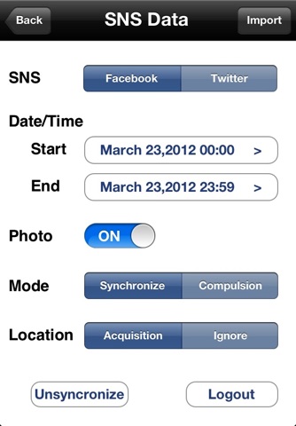
By linking it to Facebook and/or Twitter, your posts and/or tweets will be included in your "Autodiary" and displayed on the map along with your photos, etc.
The GPS unit stops when you are stopped for a long period of time, this will conserve your battery power and allow the application to run in the background for more than 24 hours.
The application has been encoded with our own error correction logic that has corrected abnormal GPS data.
All of this of course works in the background while you use you phone.
Just walk around with the application running and it will automatically record your diary information.
Its such a useful application!
Detailed Functions
1. Measurement Capabilities
-Recording stopping points
Record your stopping point for a certain period of time
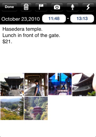
At that same place notes, voice memos, and photos can be recorded
There are four settings available:
-No - small battery consumption
Only your stopping points are recorded, not the travel route you took.
-Time - small battery consumption
Set a time for the app to start recording your travel and it will only track you during that time.
-Automatic - moderate battery in consumption (the default)
Records your movements and senses when you have stopped so it can pause the GPS tracking and save battery power
-Always - large battery consumption
Creates a detailed record of your travel routes and stopping points throughout the day
If your total daily travel time (stops not included) is more than 8 hours, please use the Time or No setting to conserve your battery power.
Battery consumption (iPhone5)
-Stopping: 0.1〜2.5%/h
-Moving: 5〜8%/h
2.Viewer Function
-Selecting date from calendar and shows movement-map of the day or aerial photography
-Shows stopping point with pin on map
-Possible to resister name for stopping point Shows registered name regarding as the same point within a fixed radius of location
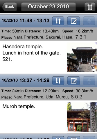
-Shows list of stopping points
Display contents: dates, stopping points (registered names or addresses or latitude and longitude), memorandums, photos and voice records
-Selecting stopping points, then displays registered memorandum in detail, photos, and plays voice memorandum
-Possible to register memorandum, photos, and voice memorandum on stopping point on later day
3.Search Mode
-Setting searching requirements, then possible to show focused records
Searching requirements:
date, distance from registered point,
whether or not you have memorandums, photos and voice memorandums
-Shows list of searching results
4.Others
-Restricts displays of viewing and research with password
-Changeable to set the distance for judging same points (Default=25m in radius)
-Three levels for setting preserving quality of Jpeg photos
-Shows changing 16 photos professional cameraman took by measurement mode
-Auto stop.
-Exports GPX,KML,KMZ file.
-Data backup/restore.
(Notes)
-At the first starting, dialogue asking if Autodiary should use GPS function will be shown.
Never fail to push approval button. Otherwise, measurement function will not work.
-When the GPS wave cannot be acquired, Autodiary uses location information from cellular phone base station.
-If your SNS data doesnt include GPS information, the application will provide data from your nearest location.
-If your SNS versions are too old, you may not be able use them.
-To use Twitter, you must have at least iOS 5.0.
-Continued use of GPS running in the background can dramatically decrease battery life.